He Usually Lived With a Female
The Life of a California Newspaperman
by George Garrigues
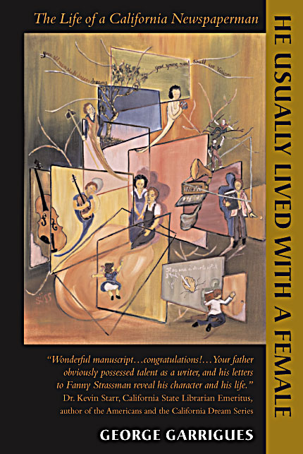
The story of Charles Harris (Brick) Garrigues, newspaperman, husband and father,
as revealed in his letters and other writing.
Internet version copyright 2002, 2006.
All rights reserved.
A Los Angeles cop once wrote about Brick Garrigues:
Sent by Grover and Gladys Johnson to S.F. to investigate for C.P. in murder trial . . .
This is the man whose ears were knocked down by Tom Cavett in 1936.
Age 30 – 6 ft. 2 in. 195 lbs. Red sandy hair. Unscrupulous writer.
Usually lives with a female.
“Man, oh, man — that guy could write, couldn’t he? I’ll bet even his shopping lists were interesting.”
Eric Weinstock
“Excellent, inspirational, professional, engaging at every turn.”
Daniel Chamberlain
“Wow! Sort of reminded me of the movie Chinatown.“
Edmond Conti
“This brought love home for me. . . . You have touched my soul . . . .”
Donna Honeycutt
Some excerpts from the book
| A Word in Front: The Author Talks With His Editor | The author of a manuscript he calls “Brick’s Book” confers with his editor, who is also his former wife, then consults his deceased father and decides to change the title. | What did the author, the editor and the father say about He Usually Lived With a Female? Click to find out. |
| Benjamin Franklin Puts the Moves on My Ancestor’s Girlfriend (1724-1903) | Ralph was ingenious, genteel in his manners, and extremely eloquent; I think I never knew a prettier talker. Ralph was inclin’d to pursue the study of poetry, not doubting but he might become eminent in it, and make his fortune by it. | So young Franklin actually had a libido, did he? Click to find out. |
| Ghosts Now, Real Then (1879-1920) | Camp County, Texas, 1879. A dying woman lies on the floor. A four-year-old girl, tiny for her age, brings the woman a drink of water. Don’t spank my baby, the woman tells the man. | And what of Beulah Dickey? Who was she and why did her dad go to prison? Click to find out. |
| The Strike at Imperial High School (1918) | I left the school and drove past the ornate old library to the Pioneers’ Museum of Imperial Valley, a surprisingly imposing structure, quite modern, where the farmers of the Valley had placed their memories, and there . . . I read about the political strife that had roiled the surface of this little agricultural community in 1918. | How did Brick Garrigues’s fellow students show their support? Click to find out. |
| Abbot Kinney, Tobacco and Venice, California (Early Twentieth Century) | Here — with a sweep of his hand — a bit of Venice, Italy. Here — with a crooking of his finger — a bit of Ostend. Here, with curious disregard of the Comstockian America that was to come, a bit of a red-light district modeled after a street in Naples. | How did a war between Greece and Turkey lead to Abbot Kinney’s fortune? Click to find out. |
| The Mysterious Letter (1925) | I held a mystery in my hand: two sheets of aged paper, browned by the passage of some seventy years, bits and pieces flaking off in my fingers, scattering on the carpet. | Who was Fanny Strassman? Click to find out. |
| Los Angeles During the Jazz Age (1927) | Los Angeles in the Jazz Age, city of dreams, city of romance. Sunshine every day. In every back yard, a swimming pool. Warm,sandy beaches. The women were all beautiful and the men handsome. Say, wasn’t that Ramon Navarro speeding down Sunset Boulevard in his white roadster? | Was that the image or the reality? Click to find out. |
| The Hateful Frank Harris: Really the Kindliest of Men (1928) | My dear girl, when [Frank] Harris leered at you, why didn’t you flash your most engaging smile? Then your great-grandchildren might have boasted of an affair their beloved ancestor had with the man who wrote those three naughty books. Such a chance doesn’t come often, even in New York! | Did writer Frank Harris answer Brick’s fan letter? Click to find out. |
| The Saint Francis Dam Disaster (1928) | It must have been three hours later that the telephone began to whirr. The voice of the city editor grated through the instrument: “Get on your clothes and get up to Ventura. There’s been a big dam break up there and plenty hell to pay. Get going.” . . . They found the girl wedged in the crotch of an uprooted tree — her tawny hair caked with mud, the laughing teeth set in a grimace of terror. | Who was the girl — and the boy she had planned to marry? Click to find out. |
| Gregor Piatigorsky ‘Discovered’ in Los Angeles (1929) | I happened to stop in just as rehearsal closed. Imagine my surprise when the conductor laid down his baton and the orchestra turned loose a flock of bravos and dashed, not for the door, but for the ‘cellist. It looked like the gang on the bench surrounding the fullback after he had run ninety-five yards to the winning touchdown. | How did Brick appoint himself the newspaper’s music critic? Click to find out. |
| Communist Presidential Candidate William Z. Foster Arrested in L.A. (1932) | Even to one accustomed to finding the devil considerably less black than he is painted, the Communist leader proves a figure of disturbing contrasts. The blue eyes are mild, gentle, almost dreamy. He smiles quizzically as he talks, so that little laugh wrinkles appear about the corners. | Why did Brick find the notorious Red a rather charming man? Click to find out. |
| After You Killed Your Grandmother Catt, What Did You Do With the Body? (1933) | Brick Garrigues wrote a regular column for the Los Angeles Illustrated Daily News, “The Spotlight.” Usually “The Spotlight” dealt seriously with local politics. Sometimes, though, Brick’s columns turned biting. | How did Brick poke fun at the Senate investigating committee? (Click to find out.) |
| You Think Fast When You’re Being Beaten Up by a D.A.’s Goon in the Hall of Justice (1936) | I didn’t know whether I was to be killed, beaten up or just robbed of the evidence I was carrying. I had no desire to be kicked where the Examiner man had been kicked. If I ran, I knew, I’d be shot —and there would be a fantastic story of my attempting to escape arrest. So I stood back and took it — giving a few myself. Fortunately, the strong-arm guy wore a heavy ring which cut my face so that I bled a lot and looked worse off than I was. | Why were the Los Angeles district attorney’s thugs out to get Brick Garrigues? Click to find out. |
| The Vanishing of Venice (1938) | In 1916 the first disaster came. Twenty-eight houses were swept into the sea. Thousands of feet of beach were destroyed. The physical disaster of Venice had begin — a disaster without loss of life but surely destroying a city. | What role did Greed play in the destruction of Venice. Calfornia? Click to find out. |
| Anna Louise Strong: The Radical Who Couldn’t Make Up Her Mind (1939) | Naomi ran into Anna Louise Strong (Remaking an American, I Change Worlds, etc.) last week while I was down south and she wanted to hire us both as a one-man secretary. . . . I’d frequently wondered what it would be like to be a guard in a bughouse, but I wonder no longer. I had two of the wildest days of leaping from place to place one could ever expect before I dashed feverishly northward to get away from her. | Why did Eleanor Roosevelt ask the noted pro-Soviet writer to go out to the West Coast? (Click to find out.) |
| While You’re Being a Soldier, Be Sure You’re Not Just Being a Sucker (1939) | When I pledge allegiance to my flag, I mean that I’ll try to make it represent the best that is in America, instead of the worst. That means not robbing other people in other countries and not using the flag to permit the robbing of Americans at home. That’s what patriotism should mean and, if it does mean that to you, you’ll be a very fine American and, if necessary, a very fine soldier. | Why did Brick’s nine-year-old son give up playing war and buy a printing press instead? (Click to find out.) |
| Ducksy: The ’38 Willys That REALLY Could (1941) | Two huge peaks on either side: rain beats down so heavily on the tin top of your car that you can scarcely tell the sound from the thunder. The car digs in and pulls as you go up and up, swinging around curves, until finally she straightens out and you seem to be pointing the nose of the car straight at the sky for the last two hundred yards. The car groans — and starts to take it and finally — just a dozen feet from the summit — she dies. | But did Ducksy make it over the Sonora Pass? (Click to find out.) |
| The Heart Attack (1945) | Brick took his flu to office with him. It seemed to be settling into his chest. I see him rubbing his shoulder, trying to breathe. He looks up from the headline he is writing, drops his pencil and squints at the editor in the center of the horseshoe-shaped desk. Brick’s usually ruddy complexion is paper-white. The editor stares, concerned: “You OK?” | What were the causes and symptoms of Brick’s heart attack? Click to find out. |
| A Socratic Dialogue (1946) | Well, writers get talked about, and everybody knows about them and they make a lot of money, if they’re good. And they are able to put over their ideas, and some of them, if they are good enough, gain lasting fame so that, hundreds of years from now, little children will be tortured by being compelled to read what they have written and write book reports upon it. | Why did Brick’s son prefer Sylvie and Bruno to Alice in Wonderland? Click to find out. |
| Just Another Day in the Life of the House Committee on Un-American Activities (1953) | Brick is questioned by a guy named Nixon, no relation to the future President. | How did Brick respond to the investigation of his political life a decade earlier? (Click to find out.) |
| In Jazz, a Shocking Call to Freedom (1961) | It is a remarkable fact that jazz, though it has grown up in the veritable shadow of social injustice, has had almost nothing to say about the grave blot on our social structure which has made most jazzmen second-class citizens and, in some section of the Nation, deprived them even of the right to be human beings. | How did Brick’s rage against social injustice find its way onto the pages of San Francisco’s leading newspaper? (Click to find out.) |
| Parkinsonism Slows Down My Father (1961-1973) | And that’s besides sitting and counting my pulse and wondering how it’s going to be when (and if) they start drilling holes in my head. | How did Brick cope with this advancing disease? (Click to find out.) |
READ MORE IN BRICK’S BOOK, MANY A GLORIOUS MORNING
Beer Bottles Scattered All Along the Path
The Most Beautiful Night of Their Lives
The Runner With Only One Shoe